
In 2011, Larry and I decided to do Mt. Whitney in August 2012. Also on the list was our friend Foon (aka Alan), but other commitments interfered for him. Fortunately, we were able to get back to a group of three, when our geocaching friend Michelle (aka shell1fish) decided to join us instead.
In order to hike Mt Whitney, you need a permit. Only 100 day-hike permits are issued per day, and you have to enter a lottery 6 months ahead of time to get one. Both Larry and I applied for permits for Aug 7th, 2012. Two months later, we learned we both were successful. Unfortunately there are no refunds for the extra permit. But, we did get our preferred date. Apparently it is rare for everyone in a group to get their permits approved, so it is advised to apply more than once as we did. The ranger at the station stated some groups apply 4 times, and none of them get it. So we were ‘lucky’ (though that ‘luck’ cost me $56.) Knowing that we were approved, we could begin our training hikes!
Training Hikes (Jun-July 2012)
Mt Whitney is no ordinary 22-mile hike. It starts at 8,300 ft and climbs up to 14,505 ft in 10.7 miles (one way). Such altitude will give anyone not used to it AMS (Acute Mountain Sickness) which can kill you. One must train for Whitney.
So, all through Spring and the first half of Summer 2012, we scheduled long, increasingly higher altitude training hikes each Saturday. Here was our schedule:
June 3rd – Mt Baldy via Ski Hut Trail 10,064′. http://www.everytrail.com/guide/mt-san-antonio-baldy-loop This was very difficult for me, and was our first high-altitude hike. By the time we got to 9000+ ft, i could only go up 100 ft before taking a break. By August, 9-10k was no problem, as we hiked 1500ft without stopping!
June 16th – Mt Baldy via Ski Lift / Devils Backbone 10,064′. I returned to Baldy with Alan for more training. This time via the ‘easier’ route. Super windy that day, we felt like we were going to be blown off the mountain!
July 7th – Mt Baden-Powell from Vincent Gap. to Islip Saddle 9400’ ~ 14 miles. Mt Baden-Powell is about 10 miles west of Wrightwood. After the 4-mile ascent to the peak, the traverse over to Islip was long with many ups and downs. Our feet hurt quite a bit by the end! But, it was very beautiful with many peaks along the way.
July 14th – Mt San Jacinto 10, 834’ ~ 11.8 mi RT Marion Mountain http://www.everytrail.com/
July 21st – Mt Baldy from Baldy Village. (planned) — This was canceled, and instead Michelle and i hiked to Mt Disappointment, San Gabriel Peak, and Mt Markham. It was 85+ degrees towards the end, but we got a good 8 miles in at about 6000 ft elevation. This is just west of Mt Wilson, and offers great panoramic views of the LA area on a clear day.
July 28th – Mt San Gorgonio from Vivian Creek 11,499′ ~18 mi RT This is the tallest peak in Southern California. Most sources say that if you can handle this hike, you are ready for Whitney. Larry could not join for this one due to hurting his knee the week before. Michelle and i set out super early and completed the hike in one day. Weather was perfect with beautiful views from the Summit.
After doing San Gorgonio, we felt ready for Whitney!
Aug 3rd – Day 1 – Drive To Independence
Michelle and I drove up together on Friday. Since we’re geocachers, we had to cache along the way. This can make road trips take much longer, but much more interesting! For those who don’t know what geocaching is, check out http://www.geocaching.com/ . We found geocaches in extremely hot desert heat in various interesting locations along the way. 106-109 does not actually feel as hot in the desert as it sounds, though! Especially when you can get right back in to an AC’d car. We took the long way, through Panamint Valley. I made sure to put about 10 Arrowhead water bottles in the back of the car, just in case we somehow got stuck out there.
Unfortunately all the hotels in Lone Pine were booked, so we stayed in a cute little place in Independence. (the Independence Inn) The owner is very nice and runs it himself.
Day 2 – Bristlecone Pine Forest Excursion
Free day in the area, Michelle suggested driving up to the Bristlecone Pine Forest for a short high-altitude hike and some Geocaching. Sounds like a great idea! We got up early-ish and headed north. She wanted to get her 5000th cache on a non-traditional cache, so we found the 13 she needed to get to 5k on our way north. One was at the beautiful Fish Hatchery —

Fish Hatchery
We fed the Trout there and enjoyed viewing the exhibits. It’s a very historic building, though no longer in operation due to fires and floods in recent years. Currently, it’s just a museum and a nice, cool place to explore on a hot day. This would also be a nice place for a wedding, i think.
After the Hatchery we found a couple more caches. One was down a dirt road about a half mile. On our way back to the main road, a minivan passed us heading down the dirt road. Who else would be out here but geocachers? I noted the sticker on the back. A few caches later, while we were on the side of the road, the minivan pulled over just past our pullout. So after finding the cache we drove up behind them and waved our GPSrs. Yep, they were fellow geocachers – from Long Beach. Nice to meet y’all. They were headed to June Lakes for some fishing and caching.
We found a cache at one of the giant VLBA (Very Large Baseline Array) antennas, and near the Caltech Radio Observatory:


After the antennas we continued east into the Ancient Bristlecone Forest National Monument.
These are the oldest trees in the world — some over 4,000 years old. The visitor center is about 10,000 ft, so it was also good elevation training. We did a 1-mile loop hike through the forest.

We got a little rained on in the forest as a high-altitude afternoon thunderstorm kicked up then left just as quickly. After our stroll we drove east a bit more into the boonies for one more cache, then back to the hotel for some Olympics. Larry (and family) arrived that evening and we had dinner at a cute little restaurant called Jenny’s in Independence. (one of about 3 restaurants in town). It was tasty, especially the blueberry pie.
Day 3 – Kearsarge Pass / Onion Valley
For additional altitude acclimation purposes, we decided to do 2 high-altitude training hikes and sleep those 2 nights at campgrounds at those higher elevations. The first one was at Onion Valley Campground.
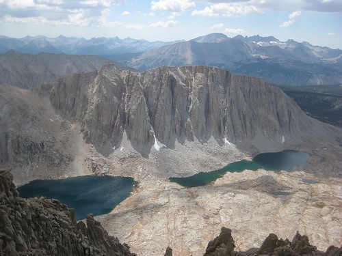
We arrived at Onion Valley early, around 7:30am and set out on a hike heading up towards Kearsarge Pass. To not over-do it, we didn’t go all the way to the pass. Instead, we took a detour to the beautiful Matlock Lake, the side trail which appeared on my GPSr:

This was a beautiful spot for lunch. We ate there, filtered some more water and headed back to the car. The hike was about 7 miles round-trip and went from 9,201 to 10,677 ft. See GPSr Track Here.
After the hike was complete. it was late enough that we could set up our reserved campsite. Unfortunately it was a ‘walk in’ campsite, so we had to lug our gear about 2-300 feet uphill from the car. This was a bit of a hassle but we managed.
We wanted showers and hot food after our day hike, so once that was set up, we headed back to Independence where Larry’s family awaited in a nice cool hotel room. Nice showers and some Olympics there cooled us off. We got some Mexican food in Lone Pine, then headed back to the campground to sleep at higher elevation. The campsite was pretty quiet and we all got some good rest.
Day 4 – Cottonwood / Trail Pass Campground / Horseshoe Meadows Hike
We got up early (6am) at Onion Valley so that we could drive down off the mountain and get started on our busy day. Just after 8 AM we arrived at the Ranger Station to pick up our Whitney permit for the next day. If not picked up by 11AM the day before, they are given up. The place was hoppin, as this is apparently ‘prime time’ of the year for Whitney Hikes. So we grabbed our pass and headed up to our new campground @ Horseshoe Meadows, which is right at the trail head for Cottonwood Lakes & Trail Pass. We planned a shorter hike up to Trail Pass taking us from 9,903 ->10,494 ft:

Horseshoe Meadow

Post hike, we again drove down to Independence – a 2+ hour round trip – for showers. After some more showering and watching of Olympics, we headed up to Whitney Portal to check it out and attempt to get some of the famous giant Whitney Pancakes and souvenirs while they were open. Unfortunately, said pancakes are only served til’ 10:30am. So, simple burgers had to do. At least we were able to get some t-shirts and such.
After dinner it was another 1 hour drive back to the campground. Whew! It would have been nice to stay in the Portal campground probably, but its generally full and also lower elevation. Once we made it back to Horseshoe, and knowing we planned to get up at 12:30 AM, we attempted to go to sleep about an hour before sunset. This was largely not successful due to the super loud campers near us. After a couple hours of listening to them gab, Michelle and I put in earplugs which actually worked incredibly well. Next time, use the earplugs!
August 7, 2012: Day 5 – Mt Whitney
12:30 AM – We wake in our tent. Approx. 4 hrs of sleep, I estimate. I saved a Diet Coke in the Bear Box, which as many know is my fuel. That was very helpful. The weather was pretty warm, in the mid 40s even at 12:15 AM.
1:15 AM – Depart Campground for Whitney Portal. 1 hr away down the mountain then back up again. Fortunately i’m pretty much nocturnal generally, so i was able to drive. Those are some steep, winding roads without any guard rails.
2:20 AM – Start up the Whitney Trail! For the first 7 hours, we made amazing time. We were targeting a 10 hour ascent, but expecting to do worse. In reality, we were on course for a 9-hour ascent by the time we hit Trail Crest. It was relatively warm until we got just above Mirror Lake. There, the trail enters an exposed ridge and the wind started to pick up with a chill. We all put on our extra layers and gloves. I’m glad i brought the gloves as i was close to not doing so. I ended up wearing them almost all day.
7:00 AM – Arrived at Trail Camp. Trail Camp is the place where (less crazy) people who do the summit in 2+ days come to camp overnight. 4:40 to Trail Camp is a great time for us, well on track to a 9 hour summit which we weren’t expecting. We filtered water here using Larry’s purifier thingy, and relaxed a bit. Lots of campers were waking up and getting ready to summit. (perhaps a little late)

Whitney Trail – Trail Camp

Filtering Water @ Trail Camp

We\’re headed there

Ben With Whitney From Trail Camp
7:15AM-9:30 AM –– We power through the legendary 97 switchbacks in 1.5 hours. We’d expected to take 2+ hours on these. Along the way, we made one snowman on the tiny bit of snow next to the trail, and met one friendly Marmot. About half way up the switchbacks, we heard (and saw) a CHP helicopter circling the valley repeatedly and hovering over various hikers. We even heard him talking on the loudspeaker sometimes. We would not find out what was going on until later..

9:30 AM – Trail Crest – At Trail Crest (top of the switchbacks), you are at the top of the ‘ridge’ that creates the Eastern Sierra, and can see West far into Sequoia national park for the first time. Just past Trail Crest, the trail meets up with the John Muir Trail. Here, we found an NPS Ranger who told us what was going on with the hiker. Apparently a man of Indian descent wearing a turban had been missing since Sunday evening. We had not seen him, but were told to keep a lookout. We found out what happened the next day.. read on 😉
The next 2.2 mile section from Trail Crest (13,600 ft) to the Summit (14,505 ft) looked not too bad on paper.
Everyone says it’s the toughest part — and they are right! Miles of stepping over and around large talus boulders in the trail, having to go down, then back up again, and having to do all this at 14,000 ft really made me hit the wall here. It took us 3 hours to make it those 2 miles, below the average 2-2.5 hr time for this section. Amazing views to the west:
View West from Trail

Larry and Ben – Almost There
12:12 PM – Almost there!

Smithsonian Hut @ Whitney
12:15 PM – Arrived at Summit!

We made it!
Finally! I got a little emotional here.
Just as i arrived the altitude hit me. I knew it was time to eat, but my stomach was feeling really unwell. I could only handle a couple bites and was worried we’d need to depart the summit quickly due to AMS. (Altitude Sickness). Foruntatly, it cleared after about 10 minutes of me lying down and we were able to spend a good (quick!) hour on top. The time up there went fast. A ranger was there looking through the Summit Register for an entry from the missing hiker. She found his log, but could not read it as it was in Indian. She also told us that the peak registers are archived in the Sequoia National Park Museum, so you should be able to find my entry there in the future! Looks like they go through a lot of pages.
We got to play a bit with the GIANT Marmot at the summit. The thing was seriously bigger than my cat. With the hundreds of hikers arriving here daily, i imagine it stays well fed from them. Apparently they can chew into backpacks if you leave them unattended, so we tried not to do that.
We played around a bit at the summit, took lots of photos, found the geocache and headed out after about an hour.


1:15 PM – Depart Summit
~4:15 PM – Descending Switchbacks – In the middle of the 97 switchbacks (right before the cable section), we started to hear thunder from the peak, and we got hailed on. The thunder that close was very loud and scary. Fortunately, we were far down from there by the time it hit. Those fabled ‘afternoon thundershowers’ are very real. It was almost perfectly clear all day, but looked like a storm by 4PM. We saw a few flashes of lightning from the peak area.
Along the way between Trail camp and Whitney Portal, we encountered a deer less than 4 feet from the trail, munching leaves and just staring at us. I didnt take a photo since i was afraid he would bolt at us, but he just kept chewin’. We also encountered an odd-looking bird (photo in master flickr set below). It was nice to see some of the waterfalls along the trail that we had missed on the way up due to darkness.
9:05 PM – Arrive back at Whitney Portal. The last few miles were pretty mind-numbing, and some of us were slow on the downhill. Many rocky ‘steps’ down made for slow going for parts. After taking an ‘after’ photo, we limped back to the car and drove down to Lone Pine for food! A tasty dinner was had at the Mt Whitney Restaurant right at the end of the Whitney Portal Road. Truly, the food wasn’t all that great, but we were so hungry that it was all amazing. I had the Whitney Burger, which was a double on a french roll. Other burgers included an Onion Valley burger and a Horseshoe Meadows burger! The place seemed to be run by teenagers.
All told, we had an amazing time. Will we do it again? Maybe!

Day 6 – Drive Home
Michelle and i slept in at the Independence Inn and drove home via Manzanar and a few other caches along the way.
When we awoke, we found an email from Larry’s wife who had found the story on the missing hiker: Overdue Hiker Shyam Das Located – apparently he had made some bad decisions (insisting on submitting after 2PM from Trail Camp! hiking alone!)- we were at trail camp by 7 AM and still didnt get back to the car til 9 PM. He had fallen off some ledges below Mirror Lake on his return trip and had a head injury. We apparently had walked right past him in the morning of our hike. Scary! He is lucky to be alive and that he was found at all. These mountains cannot be taken for granted.
See you next time.
—–
I have many more photos, If you’d like to see the full flickr sets, they can be browsed here:
WOW – thanks for sharing your story and excellent pics, Ben – proud of you guys !! xox
Congrats again, great blog entry! Such beautiful scenery, thanks for taking so many photos. Watching the slide show is like taking the hike virtually along with you guys from the comfort of home 🙂
Congratulations! Sounds amazing!